
# Original Text of the League of Nations Report and Its Armenian Translation
I present to you the original text of the League of Nations report and its Armenian translation....
Annex I — No. 2 Report and Recommendations of the Commission for the Determination of the Boundaries of Armenia
Composition of the Commission
British Empire • R. Vansittart, M.V.O. • Colonel W. H. Gribbon, C.M.G., C.B.E.
France • Monsieur Kammerer • Colonel Chardigny
Italy • Signor Galli • Colonel Castoldi
Japan • Naval Lieutenant-Commander Anno
Commission for the Determination of the Boundaries of Armenia London, 24 February 1920
After hearing the statements of the Georgian and Armenian delegations, the Commission has drawn up the present report concerning the boundaries of the future State of Armenia.
I
In determining the extent of the territory to be allotted to Armenia, three circumstances must be taken into account.
1. The number of Armenians to be returned to Turkish Armenia
According to the data currently available, that number does not exceed 500,000, of whom 150,000 are refugees in Russian Armenia, while the remainder are in Turkey or may come from Persia, Bulgaria or America.
Consequently, the Armenian territory must not be excessively extensive, so that the Armenian element may rapidly acquire predominance. The proposed boundaries take into account the possibilities for the future expansion of the people.
Under the Commission's delimitation set out below, Armenia exceeds its present capacities. At the moment of the State's creation it would have approximately 1,200,000 Armenian inhabitants in Russian Armenia and 500,000 in Turkish Armenia, that is to say, a total population of less than two million.
2. Strategic considerations
The frontier of the new State must not be excessively long in comparison with the size of its population, and must be easily defensible.
From this point of view it would be desirable to include Trebizond and Erzinjan within Armenian territory. Both are favourable points for the concentration of enemy forces, whereas their approaches are easy to defend: on the one hand along the road coming from the coast, and on the other in the defiles of the two roads leading from Erzinjan towards Kemakh and Enderes.
However, the Commission has found that, for ethnographic and political reasons, it is not expedient to detach from Turkey a region in which the Turks have always constituted a considerable majority and the Armenians only a small part of the population.
Finally, the existence on Armenia's eastern frontier of a Tatar state called Azerbaijan, which in fact has always been hostile towards Armenia, is a further reason for not extending Armenia's boundaries too far to the west. In this way it will be possible to shorten the length of Armenia's principal line of communication running from west to east, and not to include within the Armenian State an excessive number of non-Armenian elements whose inhabited territories the Armenians would be obliged to defend.
3. The necessity of securing Armenia an outlet to the sea
From this point of view Armenia finds itself in a highly unfavourable situation, since before the war the Armenian population did not extend as far as the sea coast.
It is therefore necessary to overcome this difficulty by the means proposed below.
II
Although the Commission wished to hand Trebizond over to Armenia in order to secure her an outlet of her own to the sea, the considerations set out in sections I and II have led the Commission to propose that Trebizond and Erzinjan, as well as the road connecting them, should remain within Turkey.
The Commission has examined the possibility of attaching the mining district of Gümüşhane to Armenia. However, the road connecting Erzinjan to Trebizond, which is the Erzinjan district's outlet to the sea, passes through that district. For this reason, the attachment of the Gümüşhane district to Armenia has been considered incompatible with the decision to leave Erzinjan and Trebizond under Turkish rule.
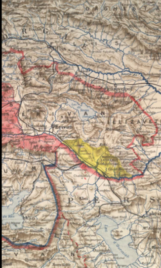
The frontier between Armenia and the Free State of Batum should be determined on the spot by an inter-Allied commission, guided by the principle that the State of Batum should be as small as possible, and that the Kars–Ardahan–Batum road, up to the frontier of that State, should belong to Armenia. Two possible boundary lines are indicated on the attached map.
As regards the frontiers between Armenia and Georgia and Azerbaijan, the Commission considers that for the time being it is expedient to await the results of the agreement provided for by the treaties existing between the three republics, according to which the States themselves are to delimit their respective frontiers.
If the republics prove unable to reach agreement on their frontiers, the question should be submitted to the arbitration of the League of Nations. The League of Nations should appoint an inter-Allied commission which will settle the frontiers on the spot, taking ethnographic data into account in principle.
The proposed northern, southern and western frontiers are set out in the attached annex.
With a view to providing Armenia with an outlet to the sea, and since it has been deemed necessary to leave Trebizond within Turkey, the Commission submits the following recommendations.
1. The creation of the Free State of Batum
Armenia will have direct contact with the Free State of Batum through the valley of the Chorokh, through which the Kars–Batum railway to be built must in future pass.
On the other hand, the frontier between Georgia and Armenia must be determined in such a way that the present road from Kars to Batum, passing through Ardahan and Artvin, remains within Armenian territory as far as the frontier of the Free State of Batum, with a sufficient defensive zone to the north.
Thus Batum will become the free port of Transcaucasia, Armenia and the eastern part of Lazistan.
It was subsequently decided to abandon the plan of granting autonomy to Lazistan. The population is in fact not ready to exercise autonomous government. Moreover, Armenia has agreed to sign the treaty we have drawn up, which provides broad guarantees for the protection of the interests of minorities.
Those provisions apply in full to Lazistan as well, and there is no reason why the Lazes should enjoy a separate special status as compared with Armenia's other minorities, which are undoubtedly far more advanced.
2. The creation of an autonomous State of Lazistan
It was initially proposed to create an autonomous State of Lazistan under the nominal sovereignty of Armenia. Armenia could subsequently convert the poor roads leading from Baiburt towards Sürmene and Of into carriage roads. The road leading to Of had been built during the war by the Russian army.
These roads lay within the zone to be allotted to the autonomous State of Lazistan.
Lazistan is a mountainous country inhabited by a primitive and uneducated Muslim population. The inhabitants are of Georgian origin — Lazes in the west, Ajars in the east — but they have no Georgian sympathies, as the events of 1914 and 1918 demonstrated.
The sympathies of these peoples, if they have any at all, are rather Turkish. Yet before the war they were in fact not particularly submissive to Turkish authority. Their chief desire is to live as independently as possible.
3. The right of free use of the Trebizond road
Armenia must have free use of the road leading from Erzerum and Baiburt to Trebizond. Trebizond, together with Platana, must become a port in which Armenia will enjoy special privileges for import and export trade.
In the hinterland of Trebizond, between Tirebolu, Ardasa and Sürmene, Turkey must not have the right to maintain troops or stores of war material. The existing fortifications of Trebizond must be demolished.
IV
The Commission deems it necessary to emphasise that, in its opinion, the creation of an Armenian State including territories formerly belonging to Turkey will be possible only if the following conditions are met.
1. The withdrawal of Turkish troops
Turkish troops must be withdrawn from the zone allotted to Armenia within the time limit set by the Allies.
Under present conditions the Turks will not withdraw their troops unless extremely strong pressure is exerted upon them.
To determine the means of exerting such pressure lies outside the Commission's terms of reference. It is, however, the Commission's duty to draw attention to this circumstance so that the necessary steps may be taken.
2. The presence of European troops or the creation of an Armenian army
Even if the Turkish troops withdraw from the former Turkish zone allotted to Armenia, the Commission is bound to state that the formation of the Armenian State will be extremely difficult without the presence of European troops.
If none of the Powers is prepared to provide such troops, the only solution will be to furnish Armenia with all the officers and war material necessary to create a strong national army.
Where possible, this army should be reinforced by volunteers recruited from among the nationals of the Allied and Associated Powers.
3. The protection of the League of Nations
In all cases Armenia must be guaranteed the protection of the League of Nations, so that she may be provided with all the material assistance necessary for the continued existence of the State and for its economic development.
Attached herewith are:
1. A map showing the boundaries of Armenia within the territories belonging to Turkey in 1914, as proposed by the Commission. 2. A map showing the approximate boundaries of Armenia, Georgia and Azerbaijan and the territories in dispute between them. 3. A map showing the two proposed solutions concerning the territory of the Free State of Batum.
Annex
Proposed line of the western boundaries of Armenia
(a) Northern frontier
The watershed of the Pontic range, from a point north-west of Mezra to the former Russo-Turkish frontier.
That watershed at present forms the boundary between the vilayets of Trebizond and Erzerum.
(b) Western frontier
From the watershed of the Pontic range north-west of Mezra to the pass of the Baiburt road, following the present boundary of the vilayets of Trebizond and Erzerum as far as Por, then in a straight line to Almali.
Thence along the Baghir Dagh, Sheitan Dagh and Chavresh Dagh ranges, along a line passing west of Ognet, along the course of the Murad Su as far as Ardushan, and terminating at the southern watershed of the Murad Su, 20 kilometres west of Mush.
The frontier must be drawn in such a way that the road linking Almali, Fam, Milikhan and Bashkey to the valley of the Charbukhur Su, west of Bingöl Dagh, remains within Armenian territory.
This was to have formed the southern frontier of the autonomous State of Lazistan. Its western frontier was carried as far as the western valley of Sürmene, so as to include the roads leading from Baiburt to Of and Sürmene.
(c) Southern frontier
The watershed bordering the plain of Mush on the south, leaving Bitlis and its environs within Armenian territory.
Thence along the range of heights bordering the southern shore of Lake Van, including the upper valley of the Jghndig Su as far as Saris, then along the southern range of the valley of the Khoshab Su as far as Barajul Dagh.
From here the frontier is formed by a line of heights running in a north-easterly direction and reaches the Persian frontier south-west of Kotur. It must be drawn in such a way that the upper valley of Bashkale remains to the Kurds.
Thence the frontier follows the former Turco-Persian frontier as far as Mount Ararat, then the former Russo-Persian frontier from Mount Ararat to a point to be determined on the river Araxes below Julfa, from which the frontier of Azerbaijan is to begin.
The boundaries of Armenia: technical description
The boundary line begins at a point to be selected on the southern shore of the Black Sea, about one kilometre west of the mouth of the Yanbol Dere, and runs in a south-